
Kishtwar Cloudburst & Rescue Operation in Jammu & Kashmir
- Digital Bookish
- 6 days ago
- 6 min read

Welcome (FBP Network)
Ladies and gentlemen, esteemed guests, first responders, partners, and members of the FBP Network—good morning and a very warm welcome to today’s special feature on “Kishtwar Cloudburst & Rescue Operation in Jammu & Kashmir.”
On behalf of FBP Network, it is my privilege to host this session that honors the courage of our rescue teams, the resilience of affected communities, and the collaborative spirit that defines disaster response in India. Today, we will revisit the sequence of events surrounding the Kishtwar cloudburst, unpack the rescue and relief operations that followed, and reflect on the lessons that can strengthen preparedness for the future.
We are also grateful to our supporters and partners who champion community awareness and capacity building. Your presence here signals a commitment to safety, accountability, and compassion.
Thank you for joining us. Let us begin.
Executive Summary
A severe cloudburst struck parts of Kishtwar district in Jammu & Kashmir, particularly impacting remote mountainous hamlets near rugged river valleys and landslide-prone slopes.
The event triggered sudden flash floods, debris flows, and structural collapses that caused casualties and extensive damage to homes, footbridges, agricultural land, and local infrastructure.
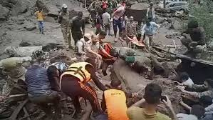
Rescue and relief operations involved a multi-agency response: local administration, J&K Police, SDRF, NDRF, Indian Army, Indian Air Force (IAF), medical teams, NGOs, and community volunteers.
The operation faced acute challenges: treacherous terrain, damaged access routes, communications breakdowns, persistent rainfall, and the risk of secondary slides.
Key takeaways include the value of early warning systems, pre-positioned resources, interoperable communications, Incident Command System (ICS) protocols, and community-led preparedness.
Note: While Kishtwar has experienced multiple cloudburst and flash-flood incidents over the years, this brief synthesizes the most widely reported operational patterns from recent events to give a complete, practically useful picture.
Understanding Cloudbursts in the Himalayas

Definition: A cloudburst is an extreme rainfall event—usually >100 mm/hour—localized over a small area in a short period.
Why Kishtwar is vulnerable:
Steep relief and narrow valleys concentrate runoff.
Young, unstable geology predisposes slopes to landslides.
Intense convection in monsoon windows can anchor over ridgelines.
Settlements close to mountain streams (nallahs) and alluvial fans are exposed to flash floods and debris flows.
Typical impacts:
Sudden surges in stream discharge, boulder-laden torrents, bank erosion.
Bridge washouts, road blockages, power and telecom outages.
House collapses, stranded populations, and disrupted medical access.
Situation Overview: Kishtwar Cloudburst

Location: Remote habitations in Kishtwar district along tributaries feeding into the Chenab river system.
Hazard sequence:
Intense, localized rainfall late night/early morning.
Rapid runoff, channel avulsion, and debris flows.
Destruction of kuccha/pucca houses and critical foot/road bridges.
Casualties, missing persons, displaced families, and livestock loss.
Initial alerts: Reports from local residents, police posts, and on-ground patrolling units; meteorological context from IMD advisories flagged heavy rainfall pockets, though exact micro-localization is inherently challenging.
The Rescue and Relief Operation: Who Did What

District Administration (DDMA): Activated Emergency Operations Centre (EOC), coordinated resources, issued public advisories, and established relief camps.
J&K Police: Secured perimeters, managed crowd and traffic, supported search-and-rescue (SAR), and maintained line-of-control for sensitive areas.
State Disaster Response Force (SDRF): Conducted SAR in high-risk zones, swift-water operations, and victim extrication.
National Disaster Response Force (NDRF): Deployed specialized teams with search equipment, medics, canine units (as available), and life-detection devices.
Indian Army: Opened access via engineering support, ropeways, temporary bridges, and provided logistics, shelters, and medical assistance.
Indian Air Force (IAF): Weather permitting, executed aerial reconnaissance, casualty evacuation (CASEVAC), and sling-load delivery of critical supplies.
Health & Medical Services: Deployed mobile medical units, triage posts, ambulances, and stabilized patients for evacuation.
Public Works and Power/Telecom Departments: Cleared roads, restored power/telecom, and deployed DG sets and temporary towers.
NGOs and Community Volunteers: Provided first response, local knowledge for access routes, food, water, clothing, and psychosocial support.
Operational Timeline (Illustrative)
Hour 0–2:
Cloudburst and flash flooding; distress calls; initial situational awareness via local police and community relays.
EOC activation; weather monitoring; first light planning.
Hour 2–6:
Forward control point set near safe access.
Quick reaction teams (Police/SDRF) move in with ropes, stretchers, basic medical kits.
Preliminary triage, identification of missing, marking unsafe structures.
Hour 6–12:
NDRF and Army elements arrive; ICS structure formalized (Incident Commander, Operations, Planning, Logistics, Safety).
Expansion of SAR grid; drone recon where feasible; establishment of communication relays (VHF/SAT phones).
Day 1–2:
Aerial recon by IAF if weather permits; CASEVAC of critical patients.
Relief camp set-up: shelter, WASH (water, sanitation, hygiene), and food distribution.
Family tracing desk established; psychosocial support initiated.
Day 3–7:
Systematic debris clearance; restoration of lifelines (roads, power, telecom).
Damage and Needs Assessment (DNA) teams deployed for household-level surveys.
Cash/relief assistance processes begin; livestock and agriculture loss assessment.
Field Challenges
Access: Washed-out approaches and landslides forced long foot approaches and rope crossings.
Weather: Intermittent rain, low cloud base, and poor visibility limited air operations.
Communications: Damaged towers and power outages necessitated VHF/SAT backups and mobile repeaters.
Safety: Risk of aftershocks in slopes—secondary slides and boulder falls—complicated SAR.
Medical: Hypothermia, crush injuries, traumatic wounds, water-borne disease risk.
Logistics: Fuel, food, potable water, and shelter materials had to be ferried cross-terrain under time pressure.
Tools and Techniques Employed
Rope rescue, river crossing systems, and stretcher carries in steep terrain.
Drones/UAVs for situational awareness (when weather allowed).
Portable life-detectors, thermal imagers, and canine units for buried victims.
Bulldozers/Excavators/JCBs for clearing debris and reopening tracks.
Temporary bridges/bailey bridges and improvised pulley systems for access.
Water purification units, chlorination, and temporary latrines for WASH.
Incident Command System (ICS) for unified, role-based coordination.
Health and Humanitarian Response
Triage categories: Immediate, Delayed, Minimal, Expectant.
On-site stabilization: IV fluids, hemorrhage control, splinting, wound care, prophylactic antibiotics as indicated.
Evacuation: Priority airlift/ambulance for polytrauma and head injuries.
Public health: Safe water, ORS distribution, vector control, and hygiene messaging.
Psychosocial: Counseling for bereaved and survivors; child-friendly spaces in camps; family tracing.
Community Role and Local Knowledge
Early alerts: Villagers upstream warned downstream hamlets; local scouts identified safe routes.
Spontaneous volunteers: Assisted with debris removal, cooking, distribution, and translation.
Women’s groups: Organized community kitchens; maintained dignity kits and privacy arrangements in shelters.
Panchayat leaders: Acted as liaisons for needs lists and beneficiary verification.
Governance and Coordination
District-level coordination: Daily briefings; public information officer for verified updates.
State/UT-level support: Resource allocation, specialized teams, and financial relief packages.
Monitoring and transparency: Beneficiary lists, grievance redressal, and helplines published by authorities.
Media and risk communication: Rumor control, safety advisories, and clear do/don’t messaging.
Lessons Learned
Early Warning and Last-Mile Delivery
Hyperlocal alerts via IMD nowcasting, Doppler radar, satellite rainfall estimates, and community sirens.
Integrate cell broadcast and multilingual voice alerts; practice seasonal drills.
Pre-Positioning and Access
Cache SAR kits, ropes, inflatable boats, and med supplies at block HQs.
Map and maintain alternate foot/rope routes; pre-identify helicopter landing sites (HLS).
Interoperable Communications
VHF networks with solar repeaters; SAT phones at Panchayat HQs.
Redundant power with portable solar and microgrids.
Risk-Sensitive Land Use
Micro-zonation of flood/landslide risk; restrict construction on alluvial fans and channel margins.
Elevate plinths; promote flood-resilient housing designs.
Training and Community Preparedness
Regular mock drills with ICS roles; school safety programs; first-aid and rope-rescue basics for volunteers.
Women-led preparedness cells for camp management and WASH.
Data and Decision Support
Real-time rainfall and stream gauges feeding into dashboards for district EOCs.
Drone-based terrain modeling post-event for reconstruction planning.
Recovery with Resilience
“Build Back Better”: safer siting, improved drainage, bioengineering of slopes (vetiver, willow), and check dams.
Livelihood revival: cash-for-work debris clearance, agri inputs, and livestock replacement.
Recommendations (Actionable)
Install community rain gauges and automatic weather stations at vulnerable sub-basins; link to siren systems.
Develop a Kishtwar-specific Flash Flood Standard Operating Procedure (SOP) with trigger levels and evacuation routes.
Maintain a volunteer roster (with contact trees) trained in basic SAR, first aid, and crowd safety.
Stockpile family kits: tarpaulins, blankets, solar lamps, water filters, ORS, and dignity kits.
Create a district-level helipad/HLS map with GPS coordinates and windsocks; conduct quarterly landing drills.
Adopt interoperable comms: program shared VHF channels for Police/SDRF/NDRF/Army.
Publish an annual pre-monsoon preparedness bulletin and conduct Panchayat-level risk walks.
Ensure transparent and rapid relief disbursal with digital beneficiary verification and grievance redressal.
Closing Remarks
The Kishtwar cloudburst response highlighted the courage of responders and the strength of communities. It also underscored that minutes matter, communications save lives, and preparedness is the most reliable defense. By investing in early warning, training, resilient infrastructure, and community leadership, we can ensure that future monsoons find us better prepared and stronger together.
Optional Annex: Quick Reference Checklists
Household Flood Readiness
Keep go-bags with IDs, medicines, water, torch, batteries, radio, and cash.
Know the nearest high ground and evacuation route.
Store documents in waterproof pouches.
Panchayat/EOC Pre-Monsoon
Test sirens and VHF sets; inventory medical and SAR supplies.
Update volunteer contact trees and transport contracts.
Mark safe shelters and display evacuation maps publicly.
SAR Team Essentials
PPE: helmets, gloves, eye protection, flotation devices.
Ropes, carabiners, stretchers, thermal blankets, first-aid, satellite comms.
Drones, life detectors, cutting tools, portable lighting, generators.
Thank you for reading and for your commitment to safer, more resilient communities.
© 2025 FBP - Fantaasco BlogPost. All rights reserved. Powered by: The F Group
Sponsored by: Fanbuluxe (fanbuluxe.in)


Comments